
Time for the first canal walk of 2013 and luckily this mid April weekend saw blue skies all day Saturday – an ideal chance for one of the longest stretches so far – just over 10 miles from Cowley Peachey Junction to Rickmansworth. This required a morning departure from home at 11:00 and resulted in a late’ish return (7 pm). Slightly daunting is the long stretch across the Colne Valley, as there are very few options for cutting the journey short if it takes too long. Armed with a SatNav, a guide book, sandwiches, water and a camera, I set out.
")
Looking back to the junction from bridge 190
")
View northwards from bridge 190
")
Bridge 189 – Benbow Bridge
")
Approaching Cowley Lock
")
Bridge 188 and a change of side for the towpath
")
Looking back from Cowley Shovel to Cowley Lock
")
Permanent moorings north of Cowley
")
Heading north from Cowley Shoevel, pipe bridges in the distance
")
Approaching pipe bridges
")
More pipe bridges
")
Uxbridge boat centre
")
Bridge 186 – Dolphin Bridge
")
Oops – looks like it burnt through
")
On the approach to Swan and Bottle bridge (185)
")
Spring blossom
")
Smallest boat of the day
")
Bridge 185 – Swan and Bottle bridge
")
Boat yard south of Uxbridge lock
")
Bridge 184
")
Looking north from bridge 184 to Uxbridge lock
")
Paddle steamer !
")
Tranquil as we approach the A40
")
Moorings south of the A40
")
Bridge 183 – White Bridge
")
View north from White Bridge – Gravel Wharf on the left
")
Denham Deep Lock
")
Between Denham Deep Lock and Denham Bridge
")
Approaching Denham bridge
")
Going about between the lock and the bridge
")
Denham Bridge (182)
")
Start of the long straight section across Harefield Moor and the Colne valley
")
Looking back along the straight
")
Rail bridge 181 – about 1/3 of the way northwards along the straight
")
Country Park sailing off to the east side
")
Moorings off to the east
")
Camouflage ?
")
Widewater bridge (180) and Widewater lock
")
Widewater lock
")
To the west of Harefield
")
Bridge 179 – NO CROSSING!
")
Tree-lined canal edge near Mount Pleasant
")
Mount Pleasant
")
Approaching Black Jack’s lock and bridge 178
")
Black Jack’s lock
")
Approaching Troy Cut
")
Rounding the bend before bridge 177
")
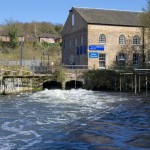
White water near Copper Mill
")
Scenic towpath north of Copper Mill Lock
")
Heading out into the countryside north of Copper Mill lock
")
The approach to Springwell Lane Bridge
")
Springwell Lane bridge (176)
")
Moorings near to abandoned warehouse
")
Stocker’s Farm
")
Looking back after Stocker’s Farm
")
Bridge 175
")
Flooded farmland near Stocker’s Lock
")
Cub scouts adventure
")
Approaching bridge 174
")
Unexpected barge in bagging area…
")
River Colne crosses the canal
I was using my Android phone and Google’s MyTracks to follow the progress of the walk. According to the GPS unit I had travelled over 16 km or 10 miles, for this section of the canal.
Total distance: 16.16 km (10.0 mi)
Total time: 3:51:21
Moving time: 3:34:21
Average speed: 4.19 km/h (2.6 mi/h)
Average moving speed: 4.52 km/h (2.8 mi/h)
Max speed: 11.71 km/h (7.3 mi/h)
Max elevation: 108 m (355 ft)
Min elevation: 55 m (180 ft)
Elevation gain: 283 m (928 ft)
View Cowley Peachey to Rickmansworth in a larger map