
")
Looking back to Dartford river crossing and QE2 bridge
")
Riverside sculpture, Frobisher Way
")
One of the partly inaccessible riverside paths at Frobisher Way, Greenhithe
")
(Looking back to) gateway into the riverside path off Pier Road
")
Finally, a riverside path to walk along
")
Abandoned (?) barge
")
A short hop over the fence near Clovely Place and we regain the path, or what is left of it
")
Rounding a small bay before we approach the fenced off land near the pier. Saint Clement anchorage.
")
Fenced off land near White’s Jetty and the ever present pylon
")
Impressive pylon – needs extra height so the wire clear tall ships
")
At the base of the pylon
")
Pylon shadow and the path (?) continues
")
Abandoned and inhabited boats, Broadness Creek
")
Raised walkway to boat and cabin
")
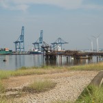
Looking out of Broadness Creek across to the docks
")
Path near the radar tower is flooded
")
Broadness Navigation light
")
Overgrown path nearing the end of the walk, muddy too – Broadness Barge road
")
The End.
Ahead the map shows that I run out of two things vital to continuation: road/rail access to within a walkable distance of the coast; and a suitable path along which to walk. So I have come as far eastwards as I can reach by foot. Ahead is an industrial complex. Tilbury docks across the water.
Live scrollable/zoomable map of the walk: