
")
Maidenhead riverside fountain
")
Maidenhead road bridge
")
Kayak and riverside at Maidenhead
")
Footpath alongside Ray Mead Road, Maidenhead
")
Boulter’s Lock
")
North of Boulter’s Lock
")
Weir at Boulter’s lock
")
Arcadian footpath approaching Cliveden
")
Riverside Cottage south of Cliveden
")
Signpost in Cookham
")
Cookham church
")
Riverside west of Cookham
")
Cookham sailing club
")
Panorama west of CSC
")
Over the rail/foot bridge at Bourne End
")
Riverside at Bourne End
")
Bourne End Marina
")
Upper Thames Sailing Club
")
")
Riverside looking across to Winter Hill
")
River passing alongside Cock Marsh
")
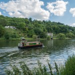
Quarry wood on the opposite bank
")
End of the walk on the approach to Marlow
Total distance: 11.01 km (6.8 mi)
Total time: 2:59:06
Moving time: 2:23:47
Average moving speed: 4.60 km/h (2.9 mi/h)
Max elevation: 87 m (285 ft)
Min elevation: 61 m (202 ft)
Live scrollable/zoomable map of the walk:
View Maidenhead To Marlow in a larger map