
Time to continue on the Grand Union Canal, this time a walk that I had to end a little earlier than planned as it took a little longer than expected and the return train journey had to be considered.
This walk is a continuation of the GUC northwards from Rickmansworth.
")
Looking back at Rickmansworth
For most of the walk, the towpath is on the left (western) side of the canal as we walk northwards.
")
Looking ahead at Rickmansworth
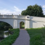
")
Bridge 173
The trickiest part of the walk is at the start where a number of waterways merge and split off at the Rickmansworth confluence – I had to backtrack at one stage as I realised I was no longer on the Canal.
")
Bridge 172 and the towpath decision at Batchworth Lock
To ensure staying on the towpath, cross over on the bridge near to the canal information centre. The hand painted lettering on the approach wall to the locks says ‘this lock’ on the one that you need to cross to.
")
Heading north after Rickmansworth
Having negotiated the confluence at Rickmansworth, the canal heads northeast for a while past some moorings.
")
Fine buildings on the opposite bank
")
Lot Mead Lock
Even though we are several miles north of the city, its presence is occasionally seen as the metropolitan underground line crosses over the canal – a juxtaposition of the old and the new transport systems.
")
London Underground line crosses the canal
In general the feeling of this walk is that of peace and quiet along leafy overhanging towpath trees. In fact, though I started the walk wearing sunglasses, I removed them a while later as parts of the walk are quite dark, due to the overhanging trees and woods to the side of the towpath.
")
Overhanging trees line the towpath
The locks and bridges on this walk are a varied mixture – locks come singly or as pairs and bridges range from simple wood and bricks to ornate stonework.
")
Cassio Bridge
")
Common Moor Lock
")
North and above Common Moor Lock
The area around Cassio Bridge Lock is quite picturesque.
")
Houses on the eastern side
")
Leafy towpath
")
Underneath the iron bridge
Various boating communities seem to have sprung up on the non-towpath side of the river – some houseboats are adorned with sheds and small buildings on the canal path.
")
Bridge 169
")
Rather attractive bridge 168
")
Iron Bridge Lock
")
New towpath near Cassiobury Park
Despite the occasional cyclist and other walkers the route was pretty quiet. Occasionally road noise evidences the presence of some major London orbital roads in the vicinity.
")
Cassiobury Park locks
")
Looking back from bridge 166 near Charlotte’s Vale
At bridge 166 it is necessary to cross to the other towpath.
")
Looking back at a barge passing under bridge 165 just before the sharp turn
At around bridge 165 the canal zig zags a while as it runs through the land surrounding The Grove, a five start hotel and resort. The canal snakes around the edge of the golf links.
")
Sharp left turn after bridge 165
Bridge 164, The Grove Bridge easily wins the prize for the nicest bridge on this walk.
")
The Grove Bridge
")
Bridge 163 north of The Grove
Don’t forget to cross to the opposite towpath at bridge 163. We remain on this side for the rest of the walk.
")
Lady Capel’s Lock
")
Road bridge 162
Road bridge 162 wins the prize for the ugliest bridge.
")
Beautiful waters edge west of Leavesden Green
")
New towpath
In several sections north of Cassio Bridge, the footpath has been renovated or is in the process of being worked on.
")
Approaching Hunton Bridge Locks
")
In need of attention
The meandering stops north of the Grove at around Hunton Bridge locks and the canal becomes more perfunctory than scenic.
")
Nice house and garden on the north eastern side
One or two nice views still await now and then but as the canal approaches the M25, the traffic noise disturbs the peace.
")
Approaching North Grove lock and the M25
On this day in late August, North Grove Lock was showing a very high water level difference.
")
A very full North Grove lock – notice the level change
")
The M25 bridge (160)
Passing underneath the M25 road bridge it was time to check on progress. Google maps had suggested that the route from Rickmansworth to Apsley would be around 8.5 miles, but as I checked my SatNav and Google MyTracks, it showed another 2.9 miles to run to Apsley and 7 miles already walked. So it seemed like there was another hour or so of walking to get to Apsley. I checked the train times and found out that Kings Langley and Apsley are on the same line to Euston and the trains heading that way on a Saturday were every 30 mins. With another hour to walk to Apsley and a possible 29 minute wait if I just missed a train, that meant another 1.5 hours awaited. The time was already approaching 6 pm and I knew that the journey home was going to take 1.5 to 2 hours.
")
Land near Home Park lock
So I checked the next due train at Kings Langeley – due in 15 minutes, picked up the pace and decided to cut the walk short by ending at Kings Langley. A quick pause atop bridge 158 for an end of route photo, and the camera was put away as I walked briskly up the hill to the train station.
")
Kings Langley Lock
A quick payment at the automatic ticket machine and my route home (Kings Langley to Euston, then down to Vauxhall for the Shepperton train was picked). A few minutes later and the train arrived signalling an end to another canal walk. A quick check on MyTracks confirmed my suspicion – it was already 7.5 miles long and despite my ever increasing walking pace, the delay at the start (724 bus from Heathrow was late and the back track around Rickmansworth confluence) meant that Apsley was one bridge too far (actually it’s another 8 bridges from Kings Langley to Apsley, but that is for another day …)
Total distance: 12.12 km (7.5 mi)
Total time: 2:35:39
Moving time: 2:24:49
Average speed: 4.67 km/h (2.9 mi/h)
Average moving speed: 5.02 km/h (3.1 mi/h)
Max speed: 7.95 km/h (4.9 mi/h)
Max elevation: 120 m (394 ft)
Min elevation: 85 m (280 ft)
Elevation gain: 125 m (409 ft)
View Rickmansworth To Kings Langley in a larger map
Just come across this Blog and your canal photos. My part of the world. Lovely to see someone else’s viewpoint. May I just make a comment as to the labelling of your photos? What you have given as Cassio Bridge Lock is in fact Common Moor Lock, the housing on the right is Byewaters. Cassio Bridge lock is the next one along beyond bridge 169.
Thank you Lynda.
I’ll correct the label if I can remember how to drive WordPress!
I can’t wait until I can get back to my long walks – I’m not yet willing to risk public transport to get me to/from them so all my current walks start and and at my house!